Products

Hawkeye 1000

Hawkeye 1000 is a versatile road survey system designed to efficiently collect and analyze data for a range of applications. Hawkeye 1000 empowers infrastructure professionals to make informed decisions and optimize road management.

Add Your Heading Text Here

Add Your Heading Text Here

Hawkeye Series

General Overview

Hawkeye 1000 is a comprehensive road survey system that combines cutting-edge technology with ease of use. It is equipped with a range of sensors and cameras to capture high-quality data on road conditions.

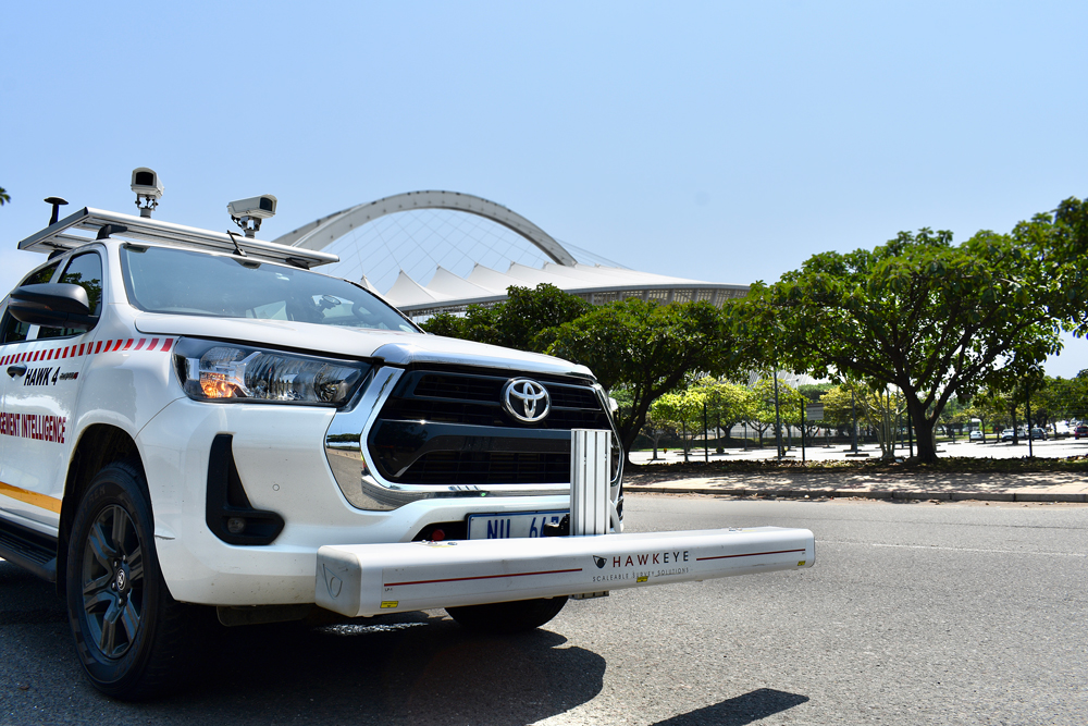
Portability, flexibility, affordability. If these are your top priorities, then the Hawkeye 1000 Series is the right tool for the job.

background graphic
Background graphic
application-icon
Affordable solutions for profiling and video data
application-icon
Operational at highway speeds to reduce survey time and costs
application-icon
Customisable modules fitted for purpose specifications
application-icon
Highly compactable and transportable with heavy duty hard case
application-icon
Includes the powerful Hawkeye Processing Toolkit software
application-icon
Supports up to 3 lasers, 3 cameras, Gipsi-Trac2 Geometry and DGPS

Digital Laser Profiler

The Digital Laser Profiler accurately records road surface roughness and texture, including MPD and SMTD, ensuring precise and reliable data for road assessments.
Hawkeye1000_Laser beam

37,282

Miles of data captured, analysed, and used to implement targeted improvements and enhance road quality

Hawkeye 1000 advanced features

Digital Laser Profiler

The Hawkeye 1000 Digital Laser Profiler captures detailed road information at high speeds, with easy detachability making it perfect for less frequent survey demands.

  • Uses modern accelerometers and precision laser sensors to compensate for vehicle body movement
  • Completely portable, utilising a detachable beam complete with a tow-bar mounting kit
  • World Bank Class 1 profiler with a choice of one, two or three laser combinations to suit all budgets
  • Can be easily shipped for remote survey requirements and short-term vehicle installations
  • Easily installed on a vehicle without special tools or technical personnel
  • Lightweight aluminium beam with external weatherproof housing
  • Results are independent of vehicle type

Available outputs

Longitudinal profile

Rut index

Roughness
(IRI, NAASRA, Ride Number, HATI)

GPS location/distance

Macrotexture (MPD and SMTD)


Used to capture roadside features and locate roads, the Hawkeye 1000 Digital Imaging System can be easily transferred between vehicles with its suction mount and transportable carry case.

  • Up to three full HD cameras can be supported (roof rack mounted option available)
  • Can be shipped for remote survey requirements and short-term vehicle installations
  • Uses .AVI storage files
  • Ideal for use on a variety of vehicles
  • Georeferencing and measurement capabilities

Available outputs

Digital imagery

Shapefiles

GPS location/distance


The newly released GIPSI-Trac2 is the next generation GNSS + INS (Global Navigation Satellite Systems + Inertial Navigation System) geometry module.

  • Uses an integrated GNSS receiver and dead-reckoning inertial sensors
  • 200Hz fused data output
  • Typical mapping accuracy of 1.2m
  • Exports to CSV and point or polyline shapefiles
  • Readily interfaces with a number of GIS packages
  • Has fully customisable GPS projection methods (Lat, Long, Easting, Northing and a range of datums)
Available outputs
GradeInertially corrected GNSS position
Cross slopeHorizontal and vertical curvature
Distance 

We are iRAP accredited

iRAP accreditation helps ensure that iRAP assessments are performed to the same consistently high level of quality worldwide. Practitioners that are accredited can become part of a market of practitioners/suppliers that are able to bid competitively to provide iRAP-specification services.

Key road assessment applications

ARRB’s cutting-edge solutions can applied in various scenarios to enhance road safety, maintenance, and overall infrastructure efficiency.
application-icon

Pavement Condition, Quality, and Road Safety Assessments

Identify and catalog roadside features such as signs, guardrails, and utility poles for inventory management and maintenance planning.

application-icon

Road Geometry and Complex Position for 3D Mapping

Collect data on road geometry (curvature, elevation, cross-section) for accurate 3D mapping and analysis.

application-icon

Locating Areas Susceptible to Damage

Identify areas prone to damage due to factors like rainfall ponding, erosion, or poor drainage.

application-icon

Pavement Condition Assessment

Accurately evaluate the overall condition of road surfaces, identifying defects, distress, and potential hazards.

application-icon

Accurate Quality Assessments

Provide precise measurements and data for quality control purposes, ensuring adherence to standards and specifications.

application-icon

Quality Control

Monitor and verify the quality of road construction and maintenance work, ensuring compliance with project requirements.

application-icon

Contract Validation

Validate the performance of contractors and ensure compliance with contract terms and specifications.

application-icon

Road Safety Assessment

Identify potential safety hazards, assess road design elements, and evaluate the effectiveness of safety measures.

application-icon

Visual Identification of Roadside Features and Assets

Identify and catalog roadside features such as signs, guardrails, utility poles, and other infrastructure elements for inventory management and maintenance planning.