案例研究

iPave:堪萨斯州运输部

美国堪萨斯州。

了解本案例研究中使用的ARRB Systems 解决方案的更多信息:

3138.22 公里

迄今为止,已在堪萨斯州各地收集了超过 1950 英里的数据。

Overview: The Kansas Road Infrastructure Challenge

iPAVe:堪萨斯州运输部

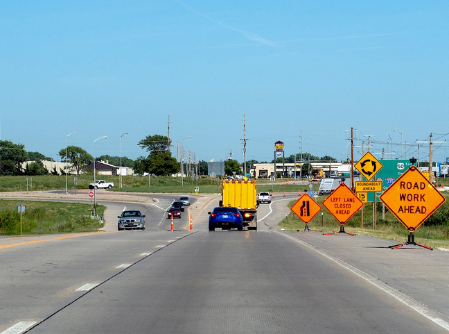
The Kansas Department of Transportation (KDOT) is responsible for over 10,000 miles of highways, used to move people and goods across the State. They oversee the construction, operation and maintenance of the network, including bridges and other transportation infrastructure.

旧方法的局限性

KDOT has collected pavement structural data utilising traditional methods for decades, to support pavement decisions and design. This has proven to be a costly endeavour and poses safety concerns. As the technology requires frequent stopping in traffic lanes to undertake the measurements, there were concerns about the ability to safely collect data, along with managing traffic control and difficulty in ensuring the necessary human resources to staff the crews.

iPAVe: Kansas Department of Transport - Case study

路面评估的新时代

In 2018, KDOT joined the Transportation Pooled Fund Study and subsequently have had iPAVe data collected almost every year since. To date, over 1,950 miles have been collected across Kansas.

In addition to the iPAVe being able to resolve their safety concerns due to the system collecting data at traffic speeds, KDOT have also recognised other benefits such as more consistent, finer resolution data, the ability to see both surface and deflection data simultaneously and a robust viewing tool in Hawkeye Insight, to tie it all together.

Advanced Sub-Surface Data Insights & Performance

Traditional Testing LimitationsModern iPAVe & Hawkeye Solution
High Safety Risks: Requires crews to stop frequently inside active traffic lanes.Traffic Speed Collection: Data is captured seamlessly at normal driving speeds, protecting road crews.
Blind to Hidden Layer Bonds: Vertical load testing misses horizontal bond tracking.Moving Load Measurement: Identifies critical sections where structural sub-layers have de-bonded.
Delayed Problem Detection: Misses early-stage underground voids.Sinkhole Identification: Successfully flags locations with anomalous deflection indicators before sinkholes breach the surface.

iPAVe data has provided KDOT with some unexpected results, including being able to identify sections of the pavement where sub-layers had de-bonded. As the iPAVe utilises a moving load measurement, data collected gives a picture of the integrity of the bonds between layers in the pavement, which is not obvious when using a vertical load collection method. Additionally, KDOT have been able to identify locations with particular deflection characteristics, as areas with potential sinkholes developing.

最重要的是,iPAVe 可为 KDOT 提供更好(更安全)、更便宜和更快速的数据,帮助其更好地管理路面。

Learn more about the ARRB Systems solutions utilized in this case study: iPAVe.

Stay Informed.
Stay Ahead.

Enter your details below to get the latest in road tech and global insights delivered straight to your inbox.