Product specifications
Hawkeye Processing Toolkit
The Hawkeye Processing Toolkit is a professional yet easy-to-use interface that enables accurate processing, analysis and management of all gathered road information.
Main features include data transfer tools, survey editing tools, video and data viewing/editing and advanced profiling. These are among just a few of the ever-growing options available for the Toolkit.
Graphical User Interface
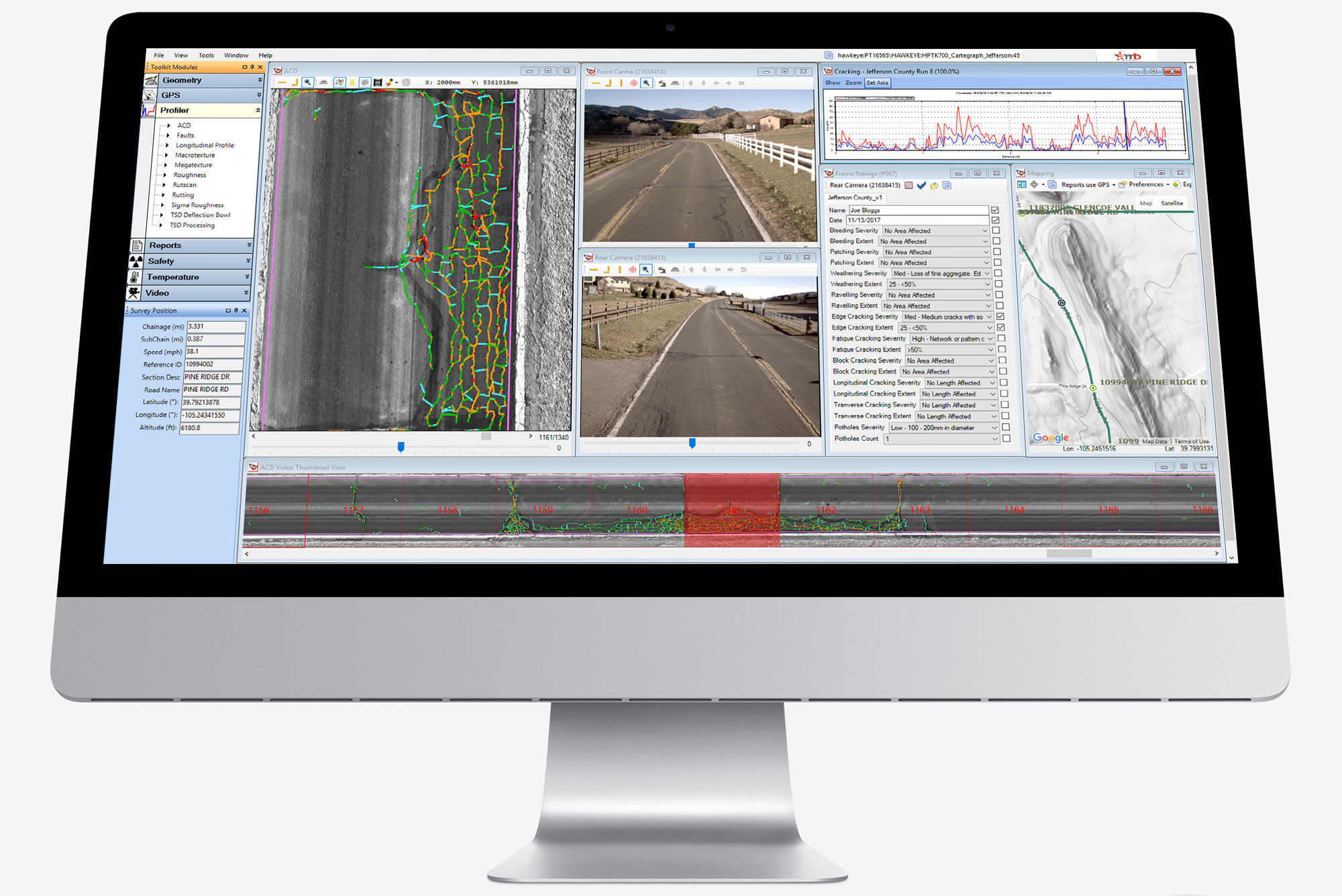
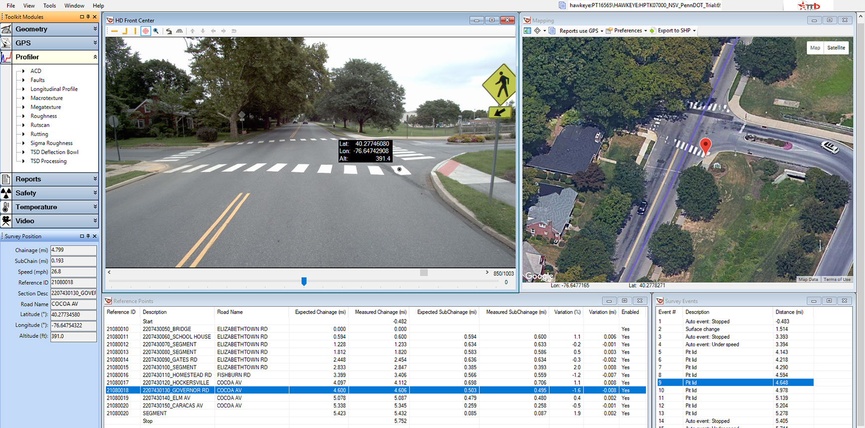
This intuitive office-based processing tool is an integrated graphical user interface (GUI) that compiles the collected survey data and allows the user to ‘virtually drive down the road’ to review and record rating information as needed.
The viewer can be used to review and rate individual video frames against chainage and GPS, save images to file, and zoom-in to inspect areas of interest.
Intelligent image processing
The Hawkeye Processing Toolkit software ensures that pavement and asset view video images can be stitched to allow for measurement across images in a panoramic view. This professional yet user-friendly feature has all the functionality you need to stitch panoramic views, rotate camera views, scale images up and down, remove fisheye effects due to lens curvature, and adjust brightness and contrast.
Geo-referencing
The Hawkeye Processing Toolkit’s powerful geo-referencing feature allows users to create an inventory of roadside assets such as signs and guard rails, and reference that image against GPS coordinates by logging the latitude, longitude and altitude of the object. This, coupled with the Hawkeye height and area measurement capabilities, ensures Asset and Road Safety Managers can create and maintain extensive inventories and risk assessments of road and roadside assets with ease.
Product features
- Easy-to-use fully graphical Windows interface allowing synchronized viewing of data, results and video
- Centralized databases to allow multiple users to process and view the same survey data simultaneously
- Advanced mapping interface that supports Google background maps
- User configurable ratings forms
- Survey search filter
- Mouse and/or configurable keyboard operation for efficient data review
- Graphical display of survey route with reference points and events
- Synchronized viewing of data, results and video
- Multiple language support: English, Chinese, Spanish, Arabic and Russian
- Easy-to-use fully graphical Windows interface allowing synchronised viewing of data, results and video
- Centralised databases to allow multiple users to process and view the same survey data simultaneously
- Advanced mapping interface that supports Google background maps
- User configurable ratings forms
- Survey search filter
- Mouse and/or configurable keyboard operation for efficient data review
- Graphical display of survey route with reference points and events
- Synchronised viewing of data, results and video
- Multiple language support: English, Chinese, Spanish, Arabic and Russian
- Batch processing and exporting
- Batch rubber banding and editable reference points
- Batch distributed processing for Automatic Crack Detection (ACD)
- Rubber banding and editable reference points
- Metric and Imperial measurement systems supported
- Extensive analysis and reporting capability for geometry, GPS, profiler and video
- Calculation of Macrotexture (MPD/ SMTD), Megatexture, IRI, rutting, longitudinal profile, and Automatic Crack Detection (ACD)
- Seamless integration with Hawkeye databases
- Windows launching allowing for cross reference of data between applications
- Windows 10 (32 and 64 bit) compatible
- Export to most PMS, GIS and HDM-4 programs, as well as CSV, PDF, MS Word, MS Excel, RTF and SHP formats